
Challenges keep things interesting. I began working on this as a personal project back in 2005. Inspired by others work, I picked it up again in 2016.
Why Hong Kong railway map?
First of all, I was born and raised in Hong Kong until adulthood. I’ve been working on my versions of Hong Kong railway maps in 2005. It was an interesting challenging to me at that point, as the two systems in Hong Kong, MTR and KCR, were to merge, and there were quite a lot of proposed extensions.
In many ways, the Hong Kong case poses some particular challenges:
- CJK + Latin bilingual contents.
- Water bodies that pedestrians may not cross.
- Lines crisscrossing in small downtown areas, with a lot of stations within close proximity.
Earlier Versions in 2005
Geographic Version, November 2005

Version 1, July 2005
- Largely followed the then-MTR official version.
- Lines easier to follow with added padding between parallel lines.
- Application of route numbers, loosely adopted from Singapore’s MRT.

Version 2, July 2005
- Some reference to the Paris Metro-RER map.
- Scale adjustments.
- Dumped route numbers.
- Background colors tuned down.
- Reduced twists and turns.
- Realigned the lines between Nam Cheong, Mei Foo and Lai King.

- Reduced twists and turns.
- Rounded turns.
- Single line stations are colored by respective lines.
- Less emphasis in geographic accuracy.
- Not featuring Light Rail system.
Version 3, July 2005

Version 4, November 2005
- Slightly geared towards geographic accuracy.
- Adjusted to a higher-contrast color scheme.
- Stations labeled in blue to accentuate the lines.

Version 5, December 2005
- Another step towards geographic accuracy.
- Wider map area, as more horizontal space is required for labeling.

The Official Version by MTR
- 90º grid, supplemented by 45º.
- Equal pitch between stations, straight lines, and clear distinctions between lines
- Legend placed on water (blue), not easy to refer to.
- Avoidable sharp route twist between Tsing Yi and Sunny Bay.

The Concentric Circles Approach
After seeing a couple of concentric attempts, I recently revisited this project. Max Roberts has been exploring circles maps in recent years. I would say the New York one is particularly interesting as a problem solving attempt, perhaps because I’m not that fond of the official one.
Hong Kong Railway Route Map ring by Sameboat, May 2016
- Easy to find routes from station A to station B.
- Orientation, proximity and natural barriers (water bodies) are mostly neglected.
MTR System Map by HKRDG, June 2016
- A derivative of Sameboat’s map.
- Received many comments on the shifted orientations.
- Many expressed disagreement on placing Whampoa station as the focal center.

My Concentric Version 1, July 2016
- General routes of supplementary services (Light Rail, Ngong Ping 360, and Kai Tak Monorail) are included.
- Future lines are shown as hollow; names of future stations are grayed out.

My Concentric Version 2, December 2016
- Larger text for lower physical size requirement.
- Legend is eliminated, line labels are applied close to the respective routes.
- Future stations are marked with gray solid dots.

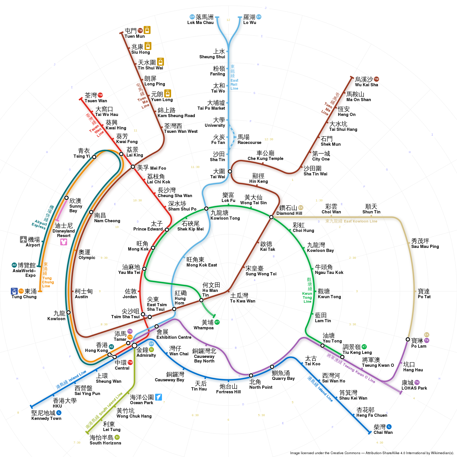
My Concentric Version 3, March 2018
- In place of line names, lines are numbered by destination, which can be used as platform numbers.

